

NH Fire Danger
|
IMPORTANT: Always check with your state fire rangers and local fire departments and wardens for the latest official information. This web page is a unofficial copy of the most recent email, and may not always be up to date. The text may be lightly edited for clarity and timeliness. Email issued by the NH Division of Forests & Lands; learn more and sign up for email alerts at their site, |
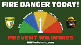
FDRAs 1-6: HIGH Fire Danger Synopsis: TODAY...Mostly sunny. Highs in the mid 70s. Northeast winds up to 10 mph. Minimum relative humidity around 36 percent. TONIGHT...Mostly cloudy. Lows in the lower 50s. Light and variable winds. Extended Fire Weather Forecast: TUESDAY...Mostly sunny. Highs in the mid 70s. Light and variable winds. Minimum relative humidity around 34 percent. TUESDAY NIGHT...Mostly clear. Lows in the lower 50s. Light and variable winds. WEDNESDAY...Sunny. Highs in the upper 70s. Light and variable winds becoming southwest around 10 mph in the afternoon. Minimum relative humidity around 31 percent. WEDNESDAY NIGHT...Mostly clear. Lows in the lower 50s. Southwest winds up to 10 mph. THURSDAY...Mostly sunny. Highs in the upper 70s. South winds 10 to 15 mph with gusts up to 25 mph. Minimum relative humidity around 36 percent. THURSDAY NIGHT...Partly cloudy with a chance of showers. Lows in the mid 50s. Chance of rain 50 percent. South winds 10 to 15 mph with gusts up to 25 mph. FRIDAY...Mostly cloudy with showers likely. Highs in the lower 70s. Chance of rain 70 percent. Southeast winds 10 to 15 mph with gusts up to 25 mph. Minimum relative humidity around 55 percent. FRIDAY NIGHT...Mostly cloudy with showers likely. Lows in the lower 50s. Chance of rain 70 percent. South winds 10 to 15 mph with gusts up to 25 mph. SATURDAY...Mostly sunny with a 40 percent chance of showers. Highs in the lower 70s. West winds 10 to 20 mph with gusts up to 30 mph. Minimum relative humidity around 40 percent. SATURDAY NIGHT...Mostly clear. Lows in the upper 40s. West winds 10 to 20 mph with gusts up to 35 mph. Also Follow Us On Twitter and Instagram- @NHForestRangers This email newsletter is a service of the State of New Hampshire Department of Natural and Cultural Resources. |
Source: https://www.nhdfl.dncr.nh.gov/sites/g/files/ehbemt866/files/documents/nh-fire-zone.pdf |