

NH Fire Danger
|
IMPORTANT: Always check with your state fire rangers and local fire departments and wardens for the latest official information. This web page is a unofficial copy of the most recent email, and may not always be up to date. The text may be lightly edited for clarity and timeliness. Email issued by the NH Division of Forests & Lands; learn more and sign up for email alerts at their site, |
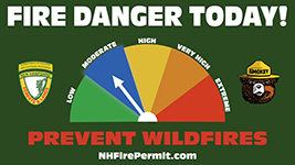
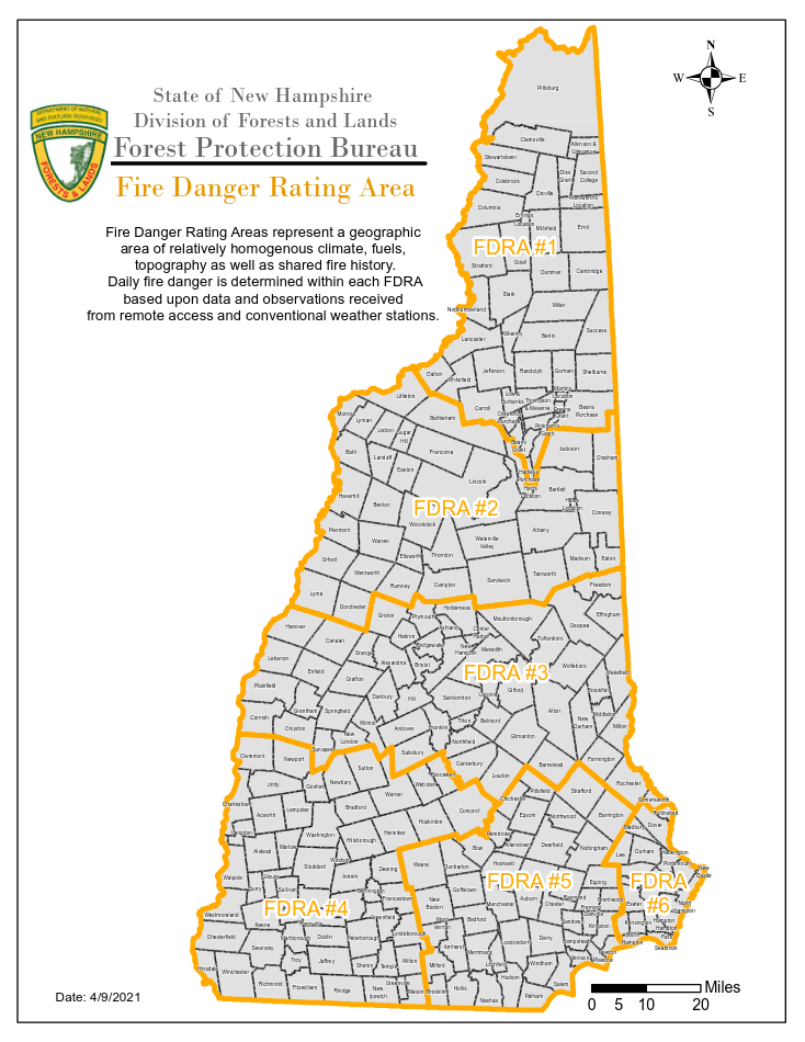
FDRAs 1-6 MODERATE Fire Danger Statewide burn ban has been lifted. Fire departments may still restrict burning due to local conditions. Fire permits required for any open burning. Synopsis: TODAY...Cloudy with a 40 percent chance of rain showers. Highs in the lower 50s. East winds 10 to 15 mph with gusts up to 25 mph. Minimum relative humidity around 59 percent. TONIGHT...Rain. Lows in the mid 40s. Chance of rain near 100 percent. East winds 15 to 25 mph with gusts up to 40 mph. Extended Fire Weather Forecast: FRIDAY...Cloudy with rain likely. Highs in the mid 50s. Chance of rain 70 percent. Southeast winds around 20 mph with gusts up to 40 mph shifting to the southwest with gusts up to 30 mph in the afternoon. Minimum relative humidity around 58 percent. FRIDAY NIGHT...Mostly cloudy with a 50 percent chance of rain showers. Lows in the upper 30s. West winds 20 to 30 mph. Gusts up to 45 mph increasing to 55 mph after midnight. SATURDAY...Partly sunny with a 50 percent chance of rain showers. Highs in the upper 40s. West winds 20 to 30 mph. Gusts up to 55 mph decreasing to 45 mph in the afternoon. Minimum relative humidity around 41 percent. SATURDAY NIGHT...Partly cloudy. Lows around 30. West winds 15 to 25 mph with gusts up to 40 mph. SUNDAY...Mostly sunny. Highs in the upper 40s. West winds 15 to 25 mph with gusts up to 40 mph. Minimum relative humidity around 38 percent. SUNDAY NIGHT...Partly cloudy. Lows in the upper 20s. West winds 10 to 20 mph with gusts up to 35 mph. MONDAY...Mostly sunny. Highs in the mid 50s. Southwest winds 10 to 15 mph with gusts up to 30 mph. Minimum relative humidity around 45 percent. MONDAY NIGHT...Mostly cloudy with a 50 percent chance of rain showers. Lows in the upper 30s. West winds 10 to 20 mph with gusts up to 35 mph. TUESDAY...Mostly sunny with a 50 percent chance of rain showers. Highs around 50. West winds 15 to 25 mph with gusts up to 40 mph. Minimum relative humidity around 40 percent. TUESDAY NIGHT...Partly cloudy. Lows in the lower 30s. West winds 15 to 25 mph with gusts up to 40 mph. WEDNESDAY...Mostly sunny. Highs in the upper 40s. Northwest winds 15 to 25 mph with gusts up to 40 mph. Minimum relative humidity around 39 percent. WEDNESDAY NIGHT...Mostly cloudy with a chance of snow showers. Lows in the lower 30s. Chance of snow 50 percent. West winds 10 to 20 mph with gusts up to 35 mph. Also Follow Us On Twitter and Instagram- @NHForestRangers This email newsletter is a service of the State of New Hampshire Department of Natural and Cultural Resources. |
Source: https://www.nhdfl.dncr.nh.gov/sites/g/files/ehbemt866/files/documents/nh-fire-zone.pdf |